|
THE PRIME MINISTER
--------
|
SOCIALIST REPUBLIC OF VIETNAM
Independence - Freedom - Happiness
---------------
|
|
No. 18/2021/QD-TTg
|
Hanoi, April 22, 2021
|
DECISION
ON NATURAL DISASTER FORECAST, WARNING AND INFORMATION TRANSMISSION AND DISASTER SEVERITY LEVELS
Pursuant to the Law on Government Organization dated June 19, 2015 and Law on Amendments to the Law on Government Organization and Law on Local Government Organization dated November 22, 2019;
Pursuant to the Law on Natural Disaster Prevention and Control dated June 19, 2013 and the Law on Amendments to the Law on Natural Disaster Prevention and Control and Law on Dikes dated June 17, 2020;
Pursuant to the Law on Hydro-meteorology dated November 23, 2015;
At the request of the Minister of Natural Resources and Environment;
The Prime Minister hereby promulgates a Decision on natural disaster forecast, warning and information transmission and disaster severity levels.
Chapter I
GENERAL PROVISIONS
Article 1. Scope
This Decision provides for natural disaster forecast, warning and information transmission and disaster severity levels serving natural disaster prevention, response and recovery in Vietnam.
Article 2. Regulated entities
This Decision applies to ministries, central authorities, local governments, organizations and individuals involved in natural disaster forecast, warning, information transmission, prevention, response and recovery; and organizations and individuals whose operations are related to natural disaster forecast, warning and information transmission.
Article 3. Types of natural disasters requiring forecast, warning and information transmission
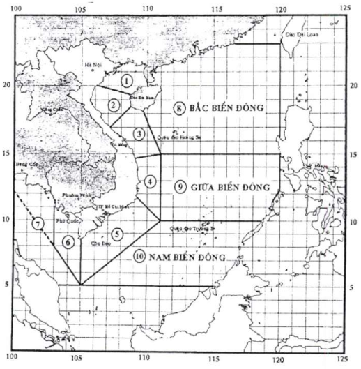
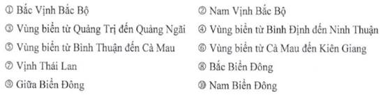
1. Storms and tropical depressions taking place in territorial waters to the west of the 120th meridian east, north of 5th parallel north and south of 23rd parallel north (hereinafter referred to as “South China Sea”, Annex I hereto) and on land within Vietnamese territory; storms and tropical depressions taking place outside of the South China Sea but may enter the South China Sea in the next 24 to 48 hours.
2. Heavy precipitation occurring within Vietnamese territory; flood on rivers situated within Vietnamese territory and relevant transboundary rivers (Annex II hereto); inundation, flash flood, landslides and subsidence that occur due to precipitation, flood or runoff within Vietnamese territory.
3. Extreme heat, drought, salt-water intrusion, landslides and subsidence within Vietnamese territory.
4. Strong breezes over the South China Sea; fog over the South China Sea and on land within Vietnamese territory.
5. Rising water levels in coastal waters and on islands of Vietnam.
6. Tornadoes, lightning, hail, cold under 13 centigrade and frost that occur within Vietnamese territory.
7. Naturally occurring wildfires in Vietnamese territory.
8. Earthquakes with a magnitude of 3.5 or more (according to Richter magnitude scale or equivalent magnitude scales) that affect Vietnam.
9. Earthquakes with a magnitude of more than 6,5 (according to Richter magnitude scale or equivalent magnitude scales) which occur at sea and may cause a tsunami that affects Vietnam.
10. Tsunamis caused by earthquakes at remote sea that potentially affect Vietnam.
Article 4. Determination of disaster severity levels
1. Disaster severity shall be classified based on intensity, impact radius, areas directly hit and potential damage.
2. Disaster severity levels shall be determined for each type of natural disaster and announced together with natural disaster forecasts and warnings.
3. Each type of natural disaster shall have no more than 5 severity levels in increasing order of severity, which are each assigned a distinct color as follows: level 1 (low risk) is assigned light blue; level 2 (moderate risk) is assigned light yellow; level 3 (high risk) is assigned orange; level 4 (very high risk) is assigned red; and level 5 (catastrophic risk) is assigned purple (Annex XII hereto).
4. Severity levels of two or more than two concurrent or successive natural disasters may be increased by one level depending on their impacts; in case of serious risk to lives and property, severity level may be increased by two levels but shall not exceed level 5.
Article 5. Interpretation of terms
For the purposes of this Decision, the terms below shall be construed as follows:
1. “tropical cyclone” refers to rotating winds (with up to hundreds of kilometers in diameter) that form over tropical seas, blow towards the eye in a counter-clockwise fashion, are characterized by low-pressure centers, cause precipitation and are occasionally accompanied by thunderstorms and tornadoes.
2. “eye” refers to the area within a tropical cyclone with the lowest atmospheric pressure where all the winds coming inside in a spiral motion converge.
3. “maximum sustained wind” refers to the highest average wind speed of a cyclone determined during 2 minutes of monitor (according to the Beaufort wind force scale, Annex III hereto).
4. “wind gust” refers to a sudden 2-second long burst of high-speed wind.
5. “strong breeze at seas” refers to average wind speed of level 6 or higher occurs at sea determined during 2 minutes of monitor (according to the Beaufort wind force scale).
6. “tropical depression” refers to a tropical cyclone whose maximum sustained wind ranges from level 6 to level 7 with potential wind gusts (Annex III hereto).
7. “tropical storm” refers to a tropical cyclone whose maximum sustained wind reaches level 8 or higher with potential wind gusts (hereinafter referred to as “storm”). “typhoon” refers to a storm whose maximum sustained wind ranges from level 10 to level 11, “strong typhoon” refers to a storm whose maximum sustained wind ranges from level 12 to level 15 and “super typhoon” refers to a storm whose maximum sustained wind reaches level 16 or higher (Annex III hereto).
8. “landfall” refers to the event in which center of a storm or a tropical depression approaches land.
9. “dissipation of storm or tropical depression” refers to the event in which a storm or a tropical depression weakens and becomes a low-pressure area whose maximum sustained wind drops below level 6.
10. “strong gale area caused by remnant of storm or tropical depression” refers to an area where strong whirlwinds of level 6 or higher occur.
11. “area suffering from direct hit of storm or tropical depression” refers to an area with bad weather, precipitation and strong breeze of level 6 or higher caused by storm or tropical depression.
12. “rising water level due to storm or tropical depression” refers to the event in which water level increases higher than normal water level due to tropical depression, storm or strong breeze at seas.
13. “rough waves caused by storm or tropical depression” refers to waves that are at least 2 meters tall and caused by storm, tropical depression or strong breeze at seas.
14. “tornado” refers to a whirlwind which is as strong as a storm in terms of wind speed, forms and dissipates in a short period of time, and affects an area from few km2 to dozens of km2.
15. “lightning” refers to electrostatic discharge within clouds, among clouds or between clouds and land.
16. “hail” refers to precipitation in form of ice balls or lumps varying in sizes and shapes that occur in a short period of time, accompanied by shower and occasional strong breeze.
17. “heavy precipitation” refers to the event in which total precipitation within 24 hours exceeds 50mm, in which “heavy rain” refers to total precipitation within 24 hours ranging from more than 50 mm to 100 mm and “very heavy rain” refers to total precipitation within 24 hours exceeding 100 mm.
18. “cold under 13 centigrade” refers to a weather phenomenon in which daily average temperature drops below 13 degrees Celsius (hereinafter referred to as “severe cold”).
19. “frost” refers to the event in which water vapor freezes and forms small, white and salt-like crystals on the ground or surfaces of plants or other objects.
20. “fog” refers to the event in which water vapor condenses into tiny droplets in the air near the Earth’s surface and reduces horizontal visibility to less than 1 km.
21. “extreme heat” refers to a weather phenomenon in which the daily highest temperature exceeds 35 degrees Celsius.
22. “drought” refers to serious water scarcity over a prolonged period of time due to no precipitation and depleted water supply.
23. “salt-water intrusion” refers to the event in which saltwater with 4‰ of salinity infiltrating deeply inland in the event of spring tide, sea level rise or depletion of freshwater aquifers.
24. “naturally occurring wildfire” refers to a wildfire caused by unusual phenomena such as prolonged drought, extreme heat and no precipitation.
25. “flood” refers to the event in which river water level rises in a definite period of time then subsides, in which:
a) “historic floods” refer to floods with the highest observed or monitored river stage or discharge;
b) “particularly large floods” refer to floods with the highest river stage or discharge rarely observed during monitoring period;
c) “irregular floods” refer to floods that occur before or after flood seasons specified in Clause 27 of this Article or floods that formed due to heavy precipitation over small areas or reservoirs or due to dam or levee failure or overflow.
26. “flash flood” refers to floods that suddenly occur on slopes and small rivers and streams on mountains and are characterized by violent current, usually accompanied by mud and debris, short timescale and destructive force.
27. “flood season” refers to a continuous period of time in a year in which floods usually occur, determined as follows:
a) For rivers in northern region: from June 15 to October 31;
b) For rivers from Thanh Hoa Province to Ha Tinh Province: from July 1 to November 30;
c) For rivers from Quang Binh Province to Ninh Thuan Province: from September 1 to December 15;
d) For rivers from Binh Thuan Province and provinces of the South and the Central Highlands: from June 15 to November 30.
28. “inundation” refers to flooding of the ground due to heavy precipitation, floods, spring tide or sea level rise.
29. “landslide” refers to the event in which soil or rocks are eroded or sliding due to precipitation, floods, runoff or drought.
30. “subsidence” refers to the event caused by precipitation, flood or runoff in which an area of land sinks to a lower level compared to the surrounding area.
31. “disaster severity level” refers to the classification of damage potentially caused by natural disasters in terms of lives, property, environment, living conditions and socio-economic activities.
32. “emergencies” refer to cases in which the natural disasters specified in Article 3 of this Decision are determined to be level 5 in terms of disaster severity and capable of causing catastrophes and inflicting heavy damage to lives, property, infrastructural constructions and the environment.
33. “earthquake” refers to the shaking of the surface of the Earth resulting from a sudden release of energy in the Earth's lithosphere that creates seismic waves capable of causing deformation and destroying houses, works, property and lives.
34. “hypocenter” refers to the point of origin of an earthquake.
35. “epicenter” refers to the vertical projection of a hypocenter to ground surface.
36. “focal depth” refers to the distance from the hypocenter to the epicenter of an earthquake.
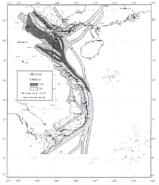
37. “intensity” (I) refers to force of shaking on ground surface caused by an earthquake and is assessed by the impact of said earthquake on houses, works, ground surface, objects and lives. In this Decision, intensity shall be assessed based on MSK-64 scale consisting of 12 degrees (Annex VIII hereto).
Relations between magnitude, type, intensity, impact and frequency of earthquakes around the world on an annual basis are specified in Annex IX. Seismic hazard map for Vietnamese territory and adjacent regions are specified in Annex X hereto.
38. “magnitude” (M) refers to level of energy emitted and radiated by an earthquake to the surrounding space in form of elastic waves. In this Decision, magnitude of an earthquake shall be assessed based on the moment magnitude scale. Earthquakes are classified into: microearthquakes (M<2,0), minor earthquakes (2,0 ≤ M ≤ 3,9), light earthquakes (4,0 ≤ M ≤ 4,9), moderate earthquakes (5,0 ≤ M ≤ 5,9), strong earthquakes (6,0 ≤ M ≤ 6,9), major earthquakes (7,0 ≤ M ≤ 7,9) and great earthquakes (M ≥ 8,0).
39. “tsunami” is a series of fast-moving waves with long periods ranging from minutes to hours. Depending on the depth of the water a tsunami is travelling through, the speed of the tsunami may reach 720 km/h or more.
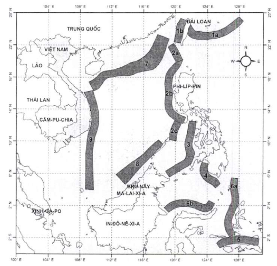
Earthquakes, volcano eruption and underwater explosions (including nuclear tests), landslides, meteorite impacts, etc. that occur at sea have the potential to generate a tsunami. Maps of earthquake sources potentially generating tsunamis that affect Vietnam are provided for in Annex XI of this Decision.
40. “areas suffering from direct hit of tsunami” refers to shallow waters along the coasts and land areas within reach of a tsunami. Depending on topographic elevation, a tsunami may make landfall kilometers deep inland.
Article 6. Regulatory bodies and organizations responsible for production of broadcasts on natural disaster forecast and warnings and disaster severity levels
1. Vietnam Meteorological Hydrological Administration affiliated to the Ministry of Natural Resources and Environment shall produce broadcasts on forecasts and warnings about the natural disasters mentioned in from Clause 1 to Clause 6 of Article 3 of this Decision and disaster severity levels thereof.
2. Vietnam Administration of Forestry affiliated to the Ministry of Agriculture and Rural Development shall produce broadcasts on forecasts and warnings about naturally occurring wildfires mentioned in Clause 7 Article 3 of this Decision and disaster severity levels thereof.
3. Institute of Geophysics affiliated to the Vietnam Academy of Science and Technology shall produce broadcasts on earthquakes and warnings about tsunamis mentioned in from Clause 8 to Clause 10 of Article 3 of this Decision and disaster severity levels thereof.
4. Broadcasts on natural disaster forecasts and warnings produced by the regulatory bodies and organizations specified in Clauses 1, 2 and 3 of this Article are official broadcasts and shall be used in directing natural disaster prevention, response and recovery in Vietnam.
Article 7. Regulatory bodies and organizations responsible for transmission and broadcasting of natural disaster forecasts and warnings
1. Voice of Vietnam, Vietnam Television and Vietnam Coastal Communication System.
2. Radio and television stations of provinces and central-affiliated cities and press agencies.
3. Regulatory bodies managing natural disaster information transmission systems.
Chapter II
NATURAL DISASTER FORECAST, WARNING AND INFORMATION TRANSMISSION
Section 1. FORECASTS AND WARNINGS ABOUT TROPICAL DEPRESSIONS, STORMS, ROUGH WAVES AND RISING WATER LEVELS DUE TO TROPICAL DEPRESSIONS AND STORMS
Article 8. Production of broadcasts on forecasts and warnings about tropical depressions, rough waves and rising water level due to tropical depressions
1. Broadcasts on tropical depressions in vicinity of South China Sea
A broadcast on a tropical depression in vicinity of South China Sea shall be produced when a tropical depression is active outside of the South China Sea and may move into the South China Sea in the next 24 hours to 48 hours.
2. Broadcasts on tropical depressions in South China Sea
A broadcast on a tropical depression in South China Sea shall be produced when a tropical depression is active in the South China Sea and unable to directly affect Vietnam’s mainland in the next 24 hours.
3. Emergency broadcasts on tropical depressions
An emergency broadcast on a tropical depression shall be produced when a tropical depression may directly affect Vietnam’s mainland in the next 24 hours.
4. Broadcasts on tropical depressions on land
A broadcast on a tropical depression on land shall be produced if:
a) The center of the tropical depression has made landfall and maximum sustained wind is of level 6 or higher; or
b) The center of the tropical depression has made landfall in another country and maximum sustained wind is of level 6 or higher and the tropical depression may directly affect Vietnam in the next 24 hours.
5. Quick broadcasts on tropical depressions
A quick broadcast on a tropical depression shall be produced together with an emergency broadcast on the tropical depression or in the event of a tropical depression with complicated developments.
6. Final broadcasts on tropical depressions
The final broadcast on a tropical depression shall be produced if:
a) The tropical depression has weakened into a low-pressure area; or
b) The tropical depression has made landfall in another country or made its exit out of Vietnamese territory and can no longer directly affect Vietnam; or
c) The tropical depression has moved out of the South China Sea and is incapable of returning to the South China Sea.
7. Broadcasts on rough waves and rising water levels due to tropical depressions
A forecast or warning broadcast on rough waves or rising water level due to a tropical depression shall be produced immediately after an emergency broadcast on the tropical depression is produced.
Article 9. Production of broadcasts on forecasts and warnings about storms, rough waves and rising water levels due to storms
1. Broadcasts on storms in vicinity of South China Sea
A broadcast on a storm in vicinity of the South China Sea shall be produced when a storm is active outside of the South China Sea and may move into South China Sea in the next 48 hours.
2. Broadcasts on storms in South China Sea
A broadcast on a storm in the South China Sea shall be produced when a storm is active in the South China Sea and unable to directly affect Vietnam’s mainland in the next 48 hours.
3. Emergency broadcasts on storms
An emergency broadcast on a storm shall be produced when a storm may directly affect Vietnam’s mainland in the next 48 hours.
4. Broadcasts on storms on land
A broadcast on a storm on land shall be produced if:
a) The center of the storm has made landfall and maximum sustained wind is of level 8 or higher; or
b) The center of the storm has made landfall in another country and maximum sustained wind is of level 8 or higher and the tropical depression may directly affect Vietnam in the next 24 to 48 hours.
5. Quick broadcasts on storms
A quick broadcast on a storm shall be produced together with an emergency broadcast on the storm or in the event of a storm with complicated activity.
6. Final broadcasts on storms
The final broadcast on a storm shall be produced if:
a) The storm has weakened into a low-pressure area; or
b) The storm has made landfall in another country or made its exit out of Vietnamese territory and can no longer directly affect Vietnam; or
c) The storm has moved out of the South China Sea and is incapable of returning to the South China Sea.
7. Broadcasts on rough waves and rising water levels due to storms
A forecast or warning broadcast on rough waves or rising water level due to a storm shall be produced immediately after an emergency broadcast on the storm is produced.
Article 10. Contents of broadcasts on forecasts and warnings about tropical depressions
1. Headlines of broadcasts on tropical depressions shall be written according to Clauses from 1 to 6 of Article 8 herein.
2. Summary on tropical depression situation in the latest update
a) Time: specified according to Hanoi time;
b) Location of the center of the tropical depression: determined by latitudes and longitudes with precision up to a tenth of a degree; in case coordinates of the center of the tropical depression cannot be determined, the center can be determined to be contained within a square whose side equals 1 degree of latitude or longitude;
c) Distance from the center of the tropical depression to one of following locations, whichever is the closest: islands or archipelagoes in the South China Sea; a specific location in mainland Vietnam or a neighboring country;
d) Intensity of the tropical depression: calculated using maximum sustained wind and wind gusts according to the Beaufort wind force scale;
dd) Direction of the tropical depression: determined using one of following 16 directions: North, North North East, North East, East North East, East, East South East, South East, South East South, South, South West South, South West, West South West, West, West North West, North West, North West North;
e) Speed: determined using km/h;
g) If a tropical depression has directly affected islands or mainland, provide monitoring figures recorded by stations located within affected areas.
3. Forecast about tropical depression activity
a) Forecast activity of the tropical depression in the next 24 hours to 48 hours with the factors mentioned in Clause 2 of this Article;
b) Forecast direction, speed and intensity of the tropical depression in the next 48 hours to 72 hours;
c) Map of predicted path of the tropical depression, radius of strong wind and areas with 70% probability that the center of tropical depression can enter;
d) Areas threatened by the tropical depression in the next 24 hours.
4. Forecast about tropical depression impact
a) Broadcasts on tropical depression in vicinity of South China Sea: forecast about the time where the tropical depression enters the South China Sea, impact of the tropical depression on territorial waters, islands or archipelagoes; potential strong winds and rough waves;
b) Broadcasts on tropical depression on South China Sea: forecast about impact of the tropical depression on territorial waters, islands or archipelagoes; potential strong winds and rough waves;
c) Emergency broadcasts on tropical depression and broadcasts on tropical depression on land: forecast about areas directly hit by the tropical depression; time and location where the tropical depression will make landfall; impact radius of wind of level 6 and level 7; heavy precipitation and other natural disasters in the next 12 hours to 24 hours;
d) The final broadcasts on tropical depression: forecast about probability of heavy precipitation and other natural disasters.
5. Detailed warning about tropical depression severity level in affected areas according to regulations in Article 4 and Article 42 of this Decision.
6. Time of broadcast and time of following broadcast.
7. Names and signatures of persons responsible for making broadcasts.
8. Quick broadcasts on tropical depressions: update the current location and intensity of the tropical depression.
Article 11. Contents of broadcasts on forecasts and warnings about storms
1. Headlines shall be written as per Clauses from 1 to 6 of Article 8 herein together with a number assigned according to the number of storms active in the South China Sea in a year; storms that are in vicinity of the South China Sea shall not be given a number.
2. Summary on storm situation in the latest update
a) Time: specified according to Hanoi time;
b) Location of center of the storm: determined by latitudes and longitudes with precision up to a tenth of a degree;
c) Distance from the center of the storm to one of following locations, whichever is the closest: islands or archipelagoes in the South China Sea; a specific location in mainland Vietnam or a neighboring country;
d) Intensity of the storm: calculated using maximum sustained wind and wind gusts according to the Beaufort wind force scale;
dd) Direction of the storm: determined using one of following 16 directions: North, North North East, North East, East North East, East, East South East, South East, South East South, South, South West South, South West, West South West, West, West North West, North West, North West North;
e) Speed: determined using km/h;
g) If a storm has directly affected islands or mainland, provide monitoring figures recorded by stations located within affected areas.
3. Forecast about storm activity
a) Forecast activity of the storm in the next 24 hours, 48 hours and up to 72 hours with the factors mentioned in Clause 2 of this Article;
b) Forecast direction, speed and intensity of the storm in the next 72 hours to 120 hours;
c) Map of predicted path of the storm, radius of strong wind and areas with 70% probability that the center of the storm can enter;
d) Areas threatened by the storm in the next 24 and 48 hours.
4. Forecast about storm impact
a) Broadcasts on storm in vicinity of South China Sea: forecast about the time where the storm enters the South China Sea, impact of the storm remnant on territorial waters, islands or archipelagoes; potential strong winds and rough waves;
b) Broadcasts on storm on South China Sea: forecast about impact of the storm remnant on territorial waters, islands or archipelagoes; potential strong winds and rough waves; areas affected by heavy storm and wind, rough waves and sea conditions in the next 24 hours, 48 hours and up to 72 hours; warnings for the next 120 hours;
c) Emergency broadcasts on storm: forecast about impact of the storm remnant on territorial waters, islands or archipelagoes; forecast about time and location where the storm will make landfall; areas affected by strong wind, heavy precipitation and other natural disasters in the next 12 hours, 24 hours and 48 hours;
d) Broadcasts on storm on land and the final broadcast on storm: forecast about areas directly hit by the storm; forecast and warnings about heavy precipitation and other natural disasters caused by storm remnant.
5. Detailed warning about storm severity level in affected areas according to regulations in Article 4 and Article 42 of this Decision.
6. Time of broadcast and time of following broadcast.
7. Names and signatures of persons responsible for making broadcasts.
8. Quick broadcasts on storm: update the current location and intensity of the storm.
Article 12. Contents of broadcasts on forecasts and warnings about rough waves and rising water levels due to tropical depressions and storms
1. Contents of forecasts and warnings about rough waves due to tropical depressions and storms
a) Headlines: forecast or warning about rough waves due to tropical depression or storm together with name of affected territorial waters;
b) Information on the highest waves, swell direction and areas with rough waves in the last 24 hours;
c) Forecasts about the highest waves, swell direction and warnings about areas with rough waves in the next 24 hours and 48 hours;
d) Time of broadcast and time of following broadcast;
dd) Names and signatures of persons responsible for making broadcasts.
2. Contents of forecasts and warnings about rising water levels due to tropical depressions and storms
a) Headlines: forecast or warning about rising water level due to tropical depression or storm together with name of affected areas;
b) Information about rising water level in areas affected by the storm or tropical depression in the last 24 hours (if any);
c) Forecasts about height and time where water rises highest, total highest water level, location of areas with highest water level around areas affected by the storm or tropical depression and remarks about risks of flooding along the shore due to a combination of rising water level and spring tide;
d) Time of broadcast and time of following broadcast;
dd) Detailed warning about severity level of rising water level according to regulations in Article 4 and Article 43 of this Decision;
e) Names and signatures of persons responsible for making broadcasts.
Article 13. Frequency and time of production of broadcasts on forecasts and warnings about tropical depressions, storms and rough waves and rising water levels due to tropical depressions and storms
1. Broadcasts on storms and tropical depressions in vicinity of South China Sea, and broadcasts on tropical depressions in South China Sea
a) 4 official broadcasts shall be produced on a daily basis at 2:00, 8:00, 14:00 and 20:00;
b) If a tropical depression in the South China Sea turns complicated, in addition to the 4 official broadcasts, further broadcasts shall be produced in-between the official broadcasts.
2. Emergency broadcasts on tropical depressions, broadcasts on tropical depressions on land, broadcasts on storms in South China Sea, emergency broadcasts on storms and broadcasts on storms on land
a) 8 official broadcasts shall be produced on a daily basis at 2:00, 5:00, 8:00, 11:00, 14:00, 17:00, 20:00 and 23:00;
b) During period of emergency broadcasts on storms or tropical depressions and in cases tropical depressions or storms in the South China Sea turn complicated, in addition to the 8 official broadcasts, further broadcasts shall be produced in-between the official broadcasts.
3. Quick broadcasts on tropical depressions and storms shall be updated on an hourly basis on the website of Vietnam Meteorological Hydrological Administration.
4. Broadcasts on forecasts and warnings about rough waves or rising water levels due to tropical depressions or storms shall be produced with frequency and time similar to production of emergency broadcasts on forecasts and warnings about storms or tropical depressions according to regulations in Clause 2 of this Article or integrated into emergency broadcasts on forecasts and warnings about storms or tropical depressions.
Section 2. FORECASTS AND WARNINGS ABOUT HEAVY PRECIPITATION, FLOOD, INUNDATION, FLASH FLOODS, LANDSLIDES AND SUBSIDENCE DUE TO PRECIPITATION, FLOOD OR RUNOFF
Article 14. Production of broadcasts on forecasts and warnings about heavy precipitation, flood, inundation, flash floods, landslides and subsidence due to precipitation, flood or runoff
1. Broadcasts on heavy precipitation forecasts and warnings
a) A broadcast on heavy precipitation warning shall be produced upon detecting probability of heavy precipitation in the next 48 hours;
b) A broadcast on heavy precipitation forecast shall be produced upon detecting probability of heavy precipitation in the next 24 hours.
2. Flood warning broadcasts
A flood warning broadcast shall be produced upon detecting probability of river water level reaching or exceeding emergency level 1 and continuing to rise or irregular flood.
3. Flood broadcasts
A flood broadcast shall be produced when river water level has reached and continues to exceed emergency level 2 or has subsided but remains higher than or at emergency level 2.
4. Emergency flood broadcasts
An emergency flood broadcast shall be produced when river water level has reached and continues to exceed emergency level 3 or has subsided but remains higher than or at emergency level 3.
5. inundation warning broadcasts
An inundation warning broadcast shall be produced upon detecting heavy precipitation, flood, spring tide or rising sea water potentially inundating affected areas or other unusual phenomena such as high risk of dam or reservoir failure or levee breach or overflow potentially inundating affected areas.
6. A warning about flash flood, landslide or subsidence due to precipitation, flood or runoff shall be produced if:
a) Heavy precipitation with probability of flash floods, landslide or subsidence over warning areas is detected; or
b) Other irregular phenomena namely dam failure, levee failure, reservoir failure and flood control with probability of flash flood, landslide or subsidence over warning areas are detected.
Article 15. Contents of forecasts and warnings about heavy precipitation, flood, inundation, flash floods, landslides and subsidence due to precipitation, flood or runoff
1. Heavy precipitation warning broadcasts
a) Headlines: heavy precipitation warning broadcast together with name of affected areas;
b) Warning about probability of heavy precipitation: duration, total amount and affected areas;
c) Warning about heavy precipitation severity level according to regulations in Article 4 and Article 44 of this Decision;
d) Time of broadcast;
dd) Names and signatures of persons responsible for making broadcasts.
2. Heavy precipitation forecast broadcasts
a) Headlines: heavy precipitation forecast broadcast together with name of affected areas;
b) Recent precipitation activity: precipitation duration, area, category and total amount in the past 24 hours;
c) Forecast about heavy precipitation in the next 24 hours to 48 hours: precipitation duration, area, category and total amount;
d) Warning about probability of heavy precipitation activity in the next 48 hours to 72 hours;
dd) Warning about heavy precipitation severity level according to regulations in Article 4 and Article 44 of this Decision;
e) Time of broadcast and time of following broadcast;
g) Names and signatures of persons responsible for making broadcasts.
3. Flood warning broadcasts
a) Headlines: flood warning broadcast together with name of region, province or river;
b) Current conditions of water level of the areas;
c) Warning: areas where flood may occur, emergency level of potential flood; probability of other accompanying natural disasters;
d) Warning about flood severity level according to regulations in Article 4 and Article 45 of this Decision;
dd) Time of broadcast;
e) Names and signatures of persons responsible for making broadcasts.
4. Flood broadcasts and emergency flood broadcasts
a) Headlines: flood broadcast and emergency flood broadcast together with name of region, province or river;
b) Current conditions of flood in the past 12 hours and water level readings recorded at the latest update;
c) Forecast: potential activity of the flood during forecasted period; forecasted water level and comparison with water level of emergency levels or with river stages of particularly large flood and historic flood;
d) Warning on probability of inundation and other accompanying natural disasters;
dd) Detailed warning about flood severity level in affected areas according to regulations in Article 4 and Article 45 of this Decision;
e) Time of broadcast and time of following broadcast;
g) Names and signatures of persons responsible for making broadcasts.
5. inundation warning broadcasts
a) Headlines: inundation warning broadcast together with name of region, province or river;
b) Current conditions of precipitation, water level, spring tide or rising sea level in the areas;
c) Warning of inundation characteristics: range, duration and largest depth;
d) Warning about inundation severity level according to regulations in Article 4 and Article 45 of this Decision;
dd) Time of broadcast;
e) Names and signatures of persons responsible for making broadcasts.
6. Broadcasts of warnings about flash flood, landslides and subsidence due to precipitation, flood or runoff
a) Headlines: broadcast of warning about flash flood, landslide or subsidence together with name of region or location;
b) Precipitation conditions over the areas in the past 6 hours;
c) Warning on precipitation for upcoming period;
d) Warning about areas at risk of flash floods, landslides or subsidence due to precipitation, flood or runoff (if any);
dd) Warning about flash flood or landslide severity level according to regulations in Article 4 and Article 46 of this Decision;
e) Time of broadcast;
g) Names and signatures of persons responsible for making broadcasts.
Article 16. Frequency and time of production of broadcasts on forecasts and warnings about heavy precipitation, flood, inundation, flash floods, landslides and subsidence due to precipitation, flood or runoff
1. Broadcasts on heavy precipitation forecasts and warnings
a) The first heavy precipitation warning broadcast shall be produced upon detecting probability of heavy precipitation over the areas; subsequent heavy precipitation warning broadcasts shall be produced on a daily basis at 9:00 and 15:30;
b) Heavy precipitation forecast broadcasts shall be produced on a daily basis at 3:30, 9:00, 15:30 and 21:00; in case of particularly heavy or extreme precipitation, produce additional broadcasts in-between official broadcasts.
2. Flood warning broadcasts
a) The first flood warning broadcast shall be produced upon detecting probability of river water level reaching or exceeding emergency level 1 or irregular flood;
b) Subsequent flood warning broadcasts shall be produced on a daily basis at 9:00 and 15:30.
3. Flood broadcasts
a) Broadcasts on flood in the Mekong Delta shall be produced every two days at 9:00; in complicated cases, produce some additional broadcasts in-between official broadcasts;
b) Broadcasts on flood on the Red River, Thai Binh River and other rivers shall be produced on a daily basis at 9:00, 15:30 and 21:00; in complicated cases, produce some additional broadcasts in-between official broadcasts.
4. Emergency flood broadcasts
a) Emergency broadcasts on flood in the Mekong Delta shall be produced on a daily basis at 9:00; in complicated cases, produce some additional broadcasts in-between official broadcasts;
b) Emergency broadcasts on flood on the Red River, Thai Binh River and other rivers shall be produced on a daily basis at 3:30, 9:00, 15:30 and 21:00; in complicated cases, produce some additional broadcasts in-between official broadcasts;
c) Flood levels on rivers shall be updated on an hourly basis on the website of Vietnam Meteorological Hydrological Administration.
5. inundation warning broadcasts
An inundation warning broadcast shall be produced upon detecting heavy precipitation, flood, spring tide or rising sea water potentially inundating affected areas or other unusual phenomena such as high risk of dam or reservoir failure or levee breach or overflow potentially inundating affected areas; inundation warning broadcasts may be produced independently or together with flood warning broadcasts, flood broadcasts and emergency flood broadcasts.
6. Broadcasts of warnings about flash flood, landslides and subsidence due to precipitation, flood or runoff
Warnings about flash floods or landslides due to precipitation, flood or runoff shall be produced upon detecting probability of flash floods, landslides or subsidence over the areas.
7. With respect to local rivers not mentioned in Annex II, regulatory bodies producing flood and inundation forecast and warning broadcasts specified in Clause 1 Article 6 of this Decision shall decide time and frequency of production of flood and inundation forecast and warning broadcasts based on requirements of flood prevention and control and characteristics of each river or river network.
Section 3. FORECASTS AND WARNINGS ABOUT EXTREME HEAT, DROUGHT, SALTWATER INTRUSION AND LANDSLIDES AND SUBSIDENCE DUE TO DROUGHT
Article 17. Production of broadcasts on forecasts and warnings about extreme heat, drought, saltwater intrusion and landslides and subsidence due to drought
1. Broadcasts on extreme heat forecasts and warnings
a) A broadcast on extreme heat warning shall be produced upon detecting probability of extreme heat in the next 48 hours;
b) A broadcast on extreme heat forecast shall be produced upon detecting probability of extreme heat in the next 24 hours.
2. Broadcasts on forecasts and warnings about drought and landslides and subsidence due to drought (if any)
A broadcast on forecast or warning about drought and landslides and subsidence due to drought (if any) shall be produced upon detecting probability of drought in the forecasted area.
3. Broadcasts on saltwater intrusion forecasts and warnings
a) A saltwater intrusion warning broadcast shall be produced upon detecting probability of saltwater intrusion in warning area;
b) A saltwater intrusion forecast broadcast shall be produced upon detecting saltwater intrusion in forecasted area.
Article 18. Contents of broadcasts on forecasts and warnings about extreme heat, drought, saltwater intrusion and landslides and subsidence due to drought
1. Extreme heat warning broadcasts
a) Headlines: broadcast on extreme heat warning over specific area;
b) Potential extreme heat warning: time of extreme heat, affected area, highest temperature;
c) Warning about extreme heat severity level according to regulations in Article 4 and Article 47 of this Decision;
d) Time of broadcast;
dd) Names and signatures of persons responsible for making broadcasts.
2. Extreme heat forecast broadcasts
a) Headlines: broadcast on extreme heat forecast over specific area;
b) Conditions of extreme heat in the past 24 hours: affected area, highest temperature, and lowest relative humidity;
c) Forecast about extreme heat in the next 24 hours to 48 hours: affected areas, highest temperature, lowest relative humidity and extreme heat period within a day;
d) Warning about probability of continuation or conclusion of extreme heat in the next 72 hours to 120 hours;
dd) Warning about extreme heat severity level according to regulations in Article 4 and Article 47 of this Decision;
e) Time of broadcast and time of following broadcast;
g) Names and signatures of persons responsible for making broadcasts.
3. Broadcasts on forecasts and warnings about drought and landslides and subsidence due to drought (if any)
a) Headlines: broadcast on forecast or warning about drought and landslides and/or subsidence due to drought (if any) together with name of potentially affected area;
b) Current conditions of total precipitation and total surface water over the forecasted or warning areas; % of insufficient precipitation and surface water compared to mean value of the same period over previous years and mean value of the same period of the immediate previous year;
c) Forecast and warning about total precipitation and total surface water over forecasted area during forecast period; % of insufficient precipitation and surface water compared to mean value of the same period over previous years;
d) Warning about landslides and subsidence due to drought (if any);
dd) Warning about levels of severity of drought or landslides and subsidence due to drought (if any) according to regulations in Article 4 and Article 48 of this Decision;
e) Time of broadcast and time of following broadcast;
g) Names and signatures of persons responsible for making broadcasts.
4. Broadcasts on saltwater intrusion warnings
a) Headlines: saltwater intrusion warning broadcast together with name of river region or area potentially affected by saltwater intrusion;
b) Current conditions of water sources and tide over the warning areas;
c) Warning about areas at risk of saltwater intrusion with 1‰ or 4‰ of salinity or higher deep inland;
d) Warning about saltwater intrusion severity level according to regulations in Article 4 and Article 49 of this Decision;
e) Time of broadcast;
d) Names and signatures of persons responsible for making broadcasts.
5. Broadcasts on saltwater intrusion forecasts
a) Headlines: saltwater intrusion forecast broadcast together with name of river region or area potentially affected by saltwater intrusion;
b) Current conditions of water sources, tides and saltwater intrusion over the warning areas: highest salinity at forecasted locations, distance between locations affected by salinity of 4‰ or 1‰ and primary estuaries;
c) Forecast: highest salinity, time of occurrence, locations, range and duration of effect of salinity of 4‰ or1‰; distance between locations affected by salinity of 4‰ or 1‰ and primary estuaries;
d) Warning about saltwater intrusion severity level according to regulations in Article 4 and Article 49 of this Decision;
dd) Time of broadcast and time of following broadcast;
e) Names and signatures of persons responsible for making broadcasts.
Article 19. Frequency and time of production of broadcasts on forecasts and warnings about extreme heat, drought and saltwater intrusion and landslides and subsidence due to drought
1. Broadcasts on extreme heat forecasts and warnings
a) The first extreme heat warning broadcast shall be produced upon detecting probability of extreme heat over the warning area; subsequent extreme heat warning broadcasts shall be produced on a daily basis at 14:30;
b) Extreme heat forecast broadcasts shall be produced on a daily basis at 8:00, 14:00 and 20:00; in case of particularly extreme heat and potential prolonged extreme heat, produce additional broadcasts in-between official broadcasts.
2. Broadcasts on forecasts and warnings about drought and landslides and subsidence due to drought (if any)
a) The first broadcast on forecast and warning about drought and landslides and subsidence due to drought (if any) shall be produced upon detecting probability of drought in the forecasted and warning area;
b) After producing the first broadcast, subsequent broadcasts on forecasts and warnings about drought and landslides and subsidence due to drought (if any) shall be produced once every 10 days on the 10th, 20th and the last day of every month; in complicated cases, additional broadcasts shall be produced in-between official broadcasts.
3. Broadcasts on saltwater intrusion forecasts and warnings
a) A saltwater intrusion warning broadcast shall be produced upon detecting probability of saltwater intrusion in warning area;
b) The first saltwater intrusion forecast broadcast shall be produced upon detecting saltwater intrusion in forecasted area.
After producing the first broadcast, subsequent saltwater intrusion forecast and warning broadcasts shall be produced once every 10 days on the 10th, 20th and the last day of every month; in complicated cases, additional broadcasts shall be produced in-between official broadcasts.
Section 4. FORECASTS AND WARNINGS ABOUT STRONG BREEZES AT SEA, ROUGH WAVES, RISING WATER LEVELS AND FOG
Article 20. Production of broadcasts on forecasts and warnings about strong breezes at sea, rough waves, rising water levels and fog
1. Production of broadcasts on forecasts and warnings about strong breezes at sea
a) A broadcast on warning about strong breezes at sea shall be produced upon detecting probability of strong breezes at sea in the next 24 to 48 hours;
b) A broadcast on forecast about strong breezes at sea shall be produced upon detecting probability of strong breezes at sea in the next 24 hours.
2. Production of broadcasts on forecasts and warnings of rough waves and rising water levels
a) Broadcasts on forecasts and warnings about rough waves and rising water levels due to tropical depressions and storms shall be produced according to regulations in Clause 7 Article 8 and Clause 7 Article 9 herein;
b) A broadcast on warning about rough waves or rising water level due to strong breezes at sea shall be produced upon detecting probability of rough waves or rising water level due to strong breezes at sea in the next 24 to 48 hours;
c) A broadcast on forecast about rough waves or rising water level due to strong breezes at sea shall be produced upon detecting probability of rough waves or rising water level due to strong breezes at sea in the next 24 hours;
3. Production of fog warning broadcasts
A fog warning broadcast shall be produced upon detecting probability of fog in the next 24 hours.
Article 21. Contents of broadcasts on forecasts and warnings about strong breezes at sea, rough waves, rising water levels and fog
1. Contents of broadcasts on forecasts and warnings about rough waves and rising water levels due to tropical depressions and storms shall conform to regulations in Article 12 herein.
2. Contents of broadcasts on warnings about strong breezes at sea and rough waves and rising water levels due to strong breezes at sea
a) Headlines: broadcast on warning about strong breezes at sea and rough waves and rising water levels due to strong breezes at sea together with name of affected area;
b) Warning about probability of strong breezes at sea and rough waves and rising water levels due to strong breezes at sea: time of occurrence and name of affected area;
c) Warning about severity levels of strong breezes at sea and rising water levels according to regulations in Article 4, Article 43 and Article 50 of this Decision;
d) Time of broadcast;
dd) Names and signatures of persons responsible for making broadcasts.
3. Contents of broadcasts on forecasts about strong breezes at sea and rough waves and rising water levels due to strong breezes at sea
a) Headlines: broadcast on forecast about strong breezes at sea and rough waves and rising water levels due to strong breezes at sea together with name of affected area;
b) Past activity of strong breezes at sea and rough waves and rising water levels due to strong breezes at sea: time of occurrence and name of affected area;
c) Forecast about activity of strong breezes at sea and rough waves and rising water levels due to strong breezes at sea in the next 24 hours: time of occurrence, name of affected area, wind force, height of rough waves and rising water level;
d) Warning about predicted activity of strong breezes at sea and rough waves and rising water levels due to strong breezes at sea in the next 24 to 48 hours;
dd) Warning about severity levels of strong breezes at sea and rising water levels according to regulations in Article 4, Article 43 and Article 50 of this Decision;
e) Time of broadcast and time of following broadcast;
g) Names and signatures of persons responsible for making broadcasts.
4. Fog warning broadcasts
a) Headlines: fog warning broadcast together with name of affected area;
b) Warning about fog probability: time of occurrence and affected area;
c) Warning about fog severity level according to regulations in Article 4 and Article 51 of this Decision;
d) Time of broadcast;
dd) Names and signatures of persons responsible for making broadcasts.
Article 22. Frequency and time of production of broadcasts on forecasts and warnings about strong breezes at sea, rough waves, rising water levels and fog
1. Broadcasts on forecasts and warnings about rough waves and rising water levels due to tropical depressions and storms shall be produced according to regulations in Clause 4 Article 13 herein.
2. Broadcasts on forecasts and warnings about strong breezes at sea and rough waves and rising water levels due to strong breezes at sea
a) The first broadcast on warning about strong breezes at sea and rough waves and rising water levels due to strong breezes at sea shall be produced upon detecting probability of strong breezes over the warning area; subsequent warning broadcasts shall be produced on a daily basis at 16:00;
b) Broadcasts on forecasts about strong breezes at sea and rough waves and rising water levels due to strong breezes at sea shall be produced on a daily basis at 04:00 and 16:00; in case of extreme and potential prolonged strong breezes at sea and rough waves and rising water levels due to strong breezes at sea, produce additional broadcasts in-between official broadcasts.
3. Fog warning broadcasts
The first fog warning broadcast shall be produced upon detecting probability of fog over the warning area; subsequent warning broadcasts shall be produced on a daily basis at 21:30. In case of prolonged fog with complicated activity, produce additional broadcasts at 04:30.
Section 5. FORECASTS AND WARNINGS ABOUT TORNADOES, LIGHTNING, HAIL, COLD UNDER 13 CENTIGRADE AND FROST
Article 23. Production of broadcasts on forecasts and warnings about tornadoes, lightning, hail, cold under 13 centigrade and frost
1. A broadcast on warning about tornado, lightning or hail shall be produced upon detecting probability of tornadoes, lightning or hail.
2. A broadcast on forecast or warning about cold under 13 centigrade or frost shall be produced upon detecting probability of cold under 13 centigrade or frost in the next 24 hours.
Article 24. Contents of broadcasts on forecasts and warnings about tornadoes, lightning, hail, cold under 13 centigrade and frost
1. Contents of broadcasts on warnings about tornadoes, lightning and hail
a) Headlines: broadcast on warning about tornado, lightning or hail over specific area;
b) Warning about probability of tornado, lightning or hail and affected area;
c) Warning about severity level of tornado, lightning or hail according to regulations in Article 4 and Article 52 of this Decision;
d) Time of broadcast;
dd) Names and signatures of persons responsible for making broadcasts.
2. Contents of broadcasts on forecasts and warnings about cold under 13 centigrade and frost
a) Headlines: broadcast on forecast or warning about cold under 13 centigrade or frost in specific area;
b) Forecast and warning about probability of cold under 13 centigrade or frost: time of occurrence and affected area;
c) Warning about severity level of cold under 13 centigrade or frost according to regulations in Article 4 and Article 53 of this Decision;
d) Time of broadcast;
dd) Names and signatures of persons responsible for making broadcasts.
Article 25. Frequency and time of production of broadcasts on forecasts and warnings about tornadoes, lightning, hail, cold under 13 centigrade and frost
1. A broadcast on warning about tornado, lightning or hail shall be produced at least 30 minutes before the phenomenon might happen. This type of broadcast shall be updated continuously according to actual situation.
2. The first broadcast on forecast or warning about cold under 13 centigrade or frost shall be produced upon detecting probability of cold under 13 centigrade or frost in forecasted or warning area; subsequent broadcasts shall be produced on a daily basis at 03:30, 09:30, 15:30 and 21:30.
Section 6. FORECASTS AND WARNINGS ABOUT NATURALLY OCCURRING WILDFIRES
Article 26. Production of forecasts and warnings about naturally occurring wildfires
A broadcast on forecast or warning about a naturally occurring wildfire shall be produced upon detecting wildfire warning level 4 or 5 according to regulations.
Article 27. Contents of broadcasts on forecasts and warnings about naturally occurring wildfires
1. Headlines: broadcast on forecast and warning about naturally occurring wildfire together with name of warning area;
2. Past wildfire development: time of occurrence, affected location; affected area and fire level.
3. Forecast or warning about area at risk of wildfire: province, district, type of forest; fire level and affected area.
4. Warning about severity level of naturally occurring wildfire according to regulations in Article 4 and Article 54 of this Decision.
5. Time of broadcast.
6. Names and signatures of persons responsible for making broadcasts.
Article 28. Frequency and time of production of broadcasts on forecasts and warnings about naturally occurring wildfires
The first broadcast on forecast or warning about a naturally occurring wildfire shall be produced upon detecting probability of a wildfire in the forecasted or warning area; subsequent broadcasts shall be produced on a daily basis at 06:00, 09:00, 12:00, 15:00, 19:00 and 21:00; in case of prolonged naturally occurring wildfire, produce additional broadcasts in-between official broadcasts.
Section 7. EARTHQUAKES BROADCASTS AND TSUNAMI WARNINGS
Article 29. Earthquake broadcasts
An earthquake broadcast shall be produced for:
1. Earthquakes with a magnitude of 3,5 or more (according to Richter magnitude scale or equivalent magnitude scales) that affect Vietnam.
2. Earthquakes with a magnitude of more than 6,5 (according to Richter magnitude scale or equivalent magnitude scales) which occur at sea and may cause a tsunami that affects Vietnam.
Article 30. Contents of earthquake broadcasts
1. Headlines of earthquake broadcasts
2. Time of earthquake: specified using both GMT and Hanoi time.
3. Location of earthquake: name of locality, coordinates of epicenter and focal depth.
4. Magnitude of the earthquake and intensity in epicenter and neighboring localities: specified using MSK-64 scale.
5. Potential consequences caused by earthquakes.
6. Earthquake severity level according to regulations in Article 4 and Article 55 of this Decision.
Article 31. Production of tsunami warnings
A tsunami warning shall be produced for:
1. Earthquakes with a magnitude of more than 6,5 (according to Richter magnitude scale or equivalent magnitude scales) which occur at sea and may cause a tsunami that affects Vietnam.
2. Tsunamis caused by earthquakes at remote sea that potentially affect Vietnam.
Article 32. Types of tsunami warnings
1. Tsunami warnings shall be classified into 3 levels:
a) First-level tsunami warnings, which shall be issued as soon as a strong earthquake and probability of tsunami are detected and people are advised to prepare for evacuation;
b) Second-level tsunami warnings, which shall be issued as soon as a non-destructive tsunami and probability of rough and damaging waves in coastal areas are detected and people are advised to prepare for evacuation;
c) Third-level tsunami warnings, which shall be issued as soon as a destructive tsunami is detected and immediate evacuation is required.
2. Broadcasts on tsunami warning cancellation
A broadcast on tsunami warning cancellation shall be produced when the tsunami did not happen as warned.
3. Final tsunami broadcasts
The final broadcast on a tsunami shall be produced when the tsunami is fully gone.
Article 33. Contents of tsunami warnings
1. Headlines: tsunami warning according to regulations in Article 32 of this Decision.
2. Tsunami assessment
a) Location, duration, intensity, coordinates of epicenter and focal depth of earthquake;
b) Probability of tsunami, severity level and area directly threatened by tsunami;
c) Wave height at coasts and duration of effect.
3. Evacuation scale depending on warning level.
4. Tsunami severity level according to regulations in Article 4 and Article 56 of this Decision.
5. Time of broadcast.
6. Names and signatures of persons responsible for making broadcasts.
Section 8. TRANSMISSION OF NATURAL DISASTER BROADCASTS
Article 34. Provision of natural disaster broadcasts
Regulatory bodies and organizations responsible for production of broadcasts on natural disaster forecasts and warnings provided for in Article 6 of this Decision shall provide these broadcasts for the regulatory bodies and organizations mentioned in Annex IV hereto.
Article 35. Time and methods of provision of natural disaster broadcasts
1. Natural disaster forecast and warning broadcasts shall be provided for the regulatory bodies and organizations mentioned in Annex IV hereto within 15 minutes after the broadcasts are completed.
2. Earthquake broadcasts and tsunami warnings shall be provided for the regulatory bodies and organizations mentioned in Annex IV hereto as soon as they are completed.
3. Methods of provision of natural disaster broadcasts
a) Public communication systems, including stationary telecommunication networks, mobile telecommunication networks and public postal networks; postal networks serving bodies of the Communist Party and the State and national defense and security, and central and local broadcasting systems;
b) Specialized information systems, including hotline systems directly serving direction and command of natural disaster prevention and control; specialized information, communication and broadcasting systems of ministries, ministerial agencies and governmental agencies; communication systems of border guards; tsunami warning systems in combination with warning systems for other natural disasters; communication systems serving natural disaster prevention and control of telecommunication enterprises.
Article 36. Policies on transmission of information on tropical depressions, storms and flood
1. For Voice of Vietnam
a) Upon receiving broadcasts on tropical depressions in vicinity of South China Sea, storms in vicinity of South China Sea, tropical depressions in South China Sea, storms in South China Sea, flood warning and flood broadcasts, give broadcasts once every 2 hours at the beginning of the hour continuously during day and night on channels of the station; if no new broadcasts are received, continue to replay the latest broadcasts;
b) Upon receiving emergency tropical depression broadcasts, landfall tropical depression broadcasts, emergency storm broadcasts, landfall storm broadcasts and emergency flood broadcasts, broadcast twice consecutively, then replay once at the beginning of the hour during both day and night on channels of the station until receiving new broadcasts or requested for different broadcasting hours by Central Steering Committee for Natural Disaster Prevention and Control and Vietnam Meteorological Hydrological Administration affiliated to Ministry of Natural Resources and Environment;
c) When replaying old broadcasts, repeat the time of broadcast production.
2. For Vietnam Television
a) Upon receiving broadcasts on tropical depressions in vicinity of South China Sea, broadcasts on tropical depressions in South China Sea, broadcasts on storms in vicinity of South China Sea, broadcasts on storms in South China Sea, flood warnings and flood broadcasts, give broadcasts in latest news programs of the station and replay once every 3 hours until receiving new broadcasts or requested for different broadcast time by Central Steering Committee for Natural Disaster Prevention and Control and Vietnam Meteorological Hydrological Administration affiliated to Ministry of Natural Resources and Environment;
b) Upon receiving emergency tropical depression broadcasts, landfall tropical depression broadcasts, emergency storm broadcasts, landfall storm broadcasts and emergency flood broadcasts, give broadcasts on all channels of the station, then replay once every 2 hours until receiving new broadcasts or requested for different broadcast hours by Central Steering Committee for Natural Disaster Prevention and Control and Vietnam Meteorological Hydrological Administration affiliated to Ministry of Natural Resources and Environment;
c) When replaying old broadcasts, repeat the time of broadcast production.
d) When giving broadcasts on natural disasters, adequately and accurately provide information and run summarized news on the screen providing basic information.
3. For Vietnam Coastal Communication Systems
a) For each type of natural disaster, severity level, scale of effect and warning recipient, the Vietnam Coastal Communication Systems shall transmit broadcasts via all means and on all radio frequencies at an appropriate rate;
b) Upon receiving broadcasts on tropical depressions in vicinity of South China Sea, broadcasts on tropical depressions in South China Sea, emergency tropical depression broadcasts, landfall tropical depression broadcasts, broadcasts on storms in vicinity of South China Sea, broadcasts on storms in South China Sea, emergency storm broadcasts and landfall storm broadcasts, the Vietnam Coastal Communication Systems shall transmit said broadcasts with following rates:
- Transmit via radiotelephones 16 sessions for every received original broadcast.
- Transmit via radiotelegraphs 2 sessions for every received original broadcast.
c) The Vietnam Coastal Communication Systems shall broadcast continuously during the day until received original broadcasts are no longer valid.
Article 37. Policies on transmission of earthquake broadcasts and tsunami warnings
1. For Voice of Vietnam and Vietnam Television
a) Earthquake broadcasts shall be transmitted once immediately after receipt and replayed in the next news broadcasts;
b) First-level and second-level tsunami warnings shall be transmitted immediately after received and replayed twice with 5 minutes interval between each instance. Repeat every 30 minutes until the final tsunami broadcast or tsunami warning cancellation broadcast is received;
c) Third-level tsunami warnings shall be transmitted immediately after received and replayed twice with 5 minutes interval between each instance. Repeat every 20 minutes until the final tsunami broadcast is received;
d) The final tsunami broadcasts or tsunami warning cancellation broadcast shall be transmitted and broadcasted once after received and replayed in the next news broadcasts.
2. For Vietnam Coastal Communication Systems and tsunami warning systems
a) First-level and second-level tsunami warnings shall be transmitted immediately after received and replayed twice with 5 minutes interval between each instance. Repeat every 15 minutes until the final tsunami broadcast or tsunami warning cancellation broadcast is received.
b) Third-level tsunami warnings shall be transmitted immediately after received and continuously replayed with 5 minutes interval between each instance until the final tsunami broadcast is received;
c) The final tsunami broadcast or tsunami warning cancellation broadcast shall be transmitted and broadcasted once after received and replayed once after 5 minutes.
Article 38. Policies on transmission of broadcasts on forecasts and warnings about naturally occurring wildfires
1. For Voice of Vietnam
a) Upon receiving broadcasts on forecasts and warnings about naturally occurring wildfires in key areas, give broadcasts on all channels of the station at different times until receiving new broadcasts or requested for different broadcast time by Central Steering Committee for Natural Disaster Prevention and Control and Vietnam Administration of Forestry affiliated to Ministry of Agriculture and Rural Development;
b) When replaying old broadcasts, repeat the time of broadcast production.
2. For Vietnam Television
a) Upon receiving broadcasts on forecasts and warnings about naturally occurring wildfires in key areas, give broadcasts on latest news programs on all channels of the station and repeat every 03 hours until receiving new broadcasts or requested for different broadcast time by Central Steering Committee for Natural Disaster Prevention and Control and Vietnam Administration of Forestry affiliated to Ministry of Agriculture and Rural Development;
b) When giving broadcasts on forecasts and warnings about naturally occurring wildfires, adequately and accurately provide information and run summarized news on the screen providing basic information.
Article 39. Policies on transmission of other natural disaster broadcasts
1. If forecasts and warnings on rough waves, rising water level, heavy precipitation, inundation, flash floods, landslides and subsidence due to precipitation, flood or runoff, extreme heat, drought, landslides and subsidence due to drought, saltwater intrusion, strong breezes at sea, fog, tornadoes, lightning, hail, cold under 13 centigrade and frost are integrated into weather forecasts, forecasts on tropical depressions, storms and flood, the transmission of said broadcasts shall comply with transmission policies of the main broadcasts.
2. If forecasts and warnings on rough waves and rising water level due to tropical depressions or storms, heavy precipitation, inundation, flash floods, landslides and subsidence due to precipitation, flood or runoff, extreme heat, drought, landslides and subsidence due to drought, saltwater intrusion, strong breezes at sea, fog, tornadoes, lightning, hail, cold under 13 centigrade and frost are made into separate broadcasts, the transmission of said broadcasts shall comply with requests of the regulatory bodies producing the broadcasts.
Article 40. Policies on transmission of emergency natural disaster declarations
Emergency natural disaster declarations shall be transmitted in compliance with regulations of law on state of emergency in the event of large disasters or dangerous epidemics.
Article 41. Transmission of natural disaster broadcasts of organizations and individuals
Organizations and individuals not mentioned in Articles 36, 37 and 38 of this Decision are recommended to transmit official natural disaster broadcasts provided by the regulatory bodies and organizations specified in Article 6 of this Decision or broadcasts made by Voice of Vietnam or Vietnam Television.
Chapter III
DISASTER SEVERITY LEVELS
Article 42. Tropical depression and storm severity levels
1. Disaster severity level 3 is applicable to the following cases:
a) Forecasted tropical depressions and storms of levels 8 and 9 in the South China Sea (including the Spratly Islands and Paracel Islands); in coastal waters; over land in the Northwest, Viet Bac area, Northeast, Red River Delta, North Central Coast, middle of Central Coast, South Central Coast, Central Highlands and Southern Vietnam;
b) Forecasted storms of levels 10 and 11 in the South China Sea (including the Spratly Islands and Paracel Islands); in coastal waters; over land in the Northwest, Viet Bac area, Northeast, Red River Delta, North Central Coast, middle of Central Coast, South Central Coast and Central Highlands;
c) Forecasted storms of levels 12 and 13 in the South China Sea (including the Spratly Islands and Paracel Islands).
2. Disaster severity level 4 is applicable to the following cases:
a) Forecasted storms of levels 10 and 11 over land in Southern Vietnam;
b) Forecasted storms of levels 12 and 13 in coastal waters; over land in the Northwest, Viet Bac area, Northeast, Red River Delta, North Central Coast, middle of Central Coast, South Central Coast and Central Highlands;
c) Forecasted storms of levels 14 and 15 in coastal waters; over land in the Northeast, Red River Delta, North Central Coast and middle Central Coast;
d) Forecasted storms of level 14 or more in the South China Sea (including the Spratly Islands and Paracel Islands).
3. Disaster severity level 5 is applicable to the following cases:
a) Forecasted storms of levels 12 and 13 over land in Southern Vietnam;
a) Forecasted storms of levels 14 and 15 over land in the Northwest, Viet Bac area, South Central Coast, Central Highlands and Southern Vietnam;
c) Forecasted storms of level 16 or more in coastal waters; over land in the Northwest, Viet Bac area, Northeast, Red River Delta, North Central Coast, middle of Central Coast, South Central Coast, Central Highlands and Southern Vietnam.
Article 43. Rising water level severity levels
1. Disaster severity level 2 is applicable to the following cases:
a) Forecast about rising water level together with tide causing water level to reach 1 to 2 meters high in total in coastal areas from Quang Binh Province to Binh Dinh Province and from Ca Mau Province to Kien Giang Province;
b) Forecast about rising water level together with tide causing water level to reach above 2 meters to 3 meters high in total in coastal areas from Nghe An Province to Ha Tinh Province and from Phu Yen Province to Ca Mau Province;
c) Forecast about rising water level together with tide causing water level to reach above 3 meters to 4 meters high in total in coastal areas from Quang Ninh Province to Thanh Hoa Province.
2. Disaster severity level 3 is applicable to the following cases:
a) Forecast about rising water level together with tide causing water level to reach above 2 meters to 3 meters high in total in coastal areas from Quang Binh Province to Binh Dinh Province and from Ca Mau Province to Kien Giang Province;
b) Forecast about rising water level together with tide causing water level to reach above 3 meters to 4 meters high in total in coastal areas from Nghe An Province to Ha Tinh Province and from Binh Thuan Province to Ca Mau Province;
c) Forecast about rising water level together with tide causing water level to reach above 4 meters to 5 meters high in total in coastal areas from Quang Ninh Province to Thanh Hoa Province;
d) Forecast about rising water level together with tide causing water level to reach above 3 meters high in total in coastal areas from Phu Yen Province to Ninh Thuan Province.
3. Disaster severity level 4 is applicable to the following cases:
a) Forecast about rising water level together with tide causing water level to reach above 3 meters to 4 meters high in total in coastal areas from Quang Binh Province to Thua Thien Hue Province;
b) Forecast about rising water level together with tide causing water level to reach above 4 meters to 5 meters high in total in coastal areas from Nghe An Province to Thua Thien Hue Province;
c) Forecast about rising water level together with tide causing water level to reach above 5 meters to 6 meters high in total in coastal areas from Quang Ninh Province to Ha Tinh Province;
d) Forecast about rising water level together with tide causing water level to reach above 3 meters high in total in coastal areas from Da Nang to Binh Dinh Province and from Ca Mau Province to Kien Giang Province;
dd) Forecast about rising water level together with tide causing water level to reach above 4 meters high in total in coastal areas from Binh Thuan Province to Ca Mau Province.
4. Disaster severity level 5 is applicable to the following cases:
a) Forecast about rising water level together with tide causing water level to reach above 5 meters high in total in coastal areas from Quang Binh Province to Thua Thien Hue Province;
b) Forecast about rising water level together with tide causing water level to reach above 6 meters high in total in coastal areas from Quang Ninh Province to Ha Tinh Province.
Article 44. Heavy precipitation severity levels
1. Disaster severity level 1 is applicable to forecasted rainfall ranging from 100 mm to 200 mm in 24 hours or from 50 mm to 100 mm in 12 hours and lasting from 1 to 2 days in midlands, mountainous areas, deltas or coastal areas covering less than half of the districts or communes of a province or multiple provinces faraway from each other.
2. Disaster severity level 2 is applicable to the following cases:
a) Forecasted rainfall ranging from 100 mm to 200 mm in 24 hours or from 50 mm to 100 mm in 12 hours and lasting from more than 2 days to 4 days in midlands or mountainous areas and more than 2 days in deltas or coastal areas covering more than half of the districts or communes of a province;
b) Forecasted rainfall ranging from 200 mm to 400 mm in 24 hours and lasting from 1 to 2 days in midlands, highlands, deltas or coastal areas covering more than half of the districts or communes of a province.
3. Disaster severity level 3 is applicable to the following cases:
a) Forecasted rainfall ranging from 100 mm to 200 mm in 24 hours or from 50 mm to 100 mm in 12 hours and lasting more than 4 days in midlands or mountainous areas covering multiple provinces;
b) Forecasted rainfall ranging from 200 mm to 400 mm in 24 hours and lasting from more than 2 to 4 days in midlands or highlands or more than 2 days in deltas or coastal areas covering multiple provinces;
c) Forecasted rainfall of more than 400 mm in 24 hours and lasting from 1 to 2 days in midlands or highlands or from 1 to 4 days in deltas and coastal areas covering multiple provinces.
4. Disaster severity level 4 is applicable to the following cases:
a) Forecasted rainfall ranging from 200 mm to 400 mm in 24 hours and lasting more than 4 days in midlands or highlands covering multiple provinces;
b) Forecasted rainfall of more than 400 mm in 24 hours and lasting for 2 days or more in midlands or highlands or more than 4 days in deltas or coastal areas covering multiple provinces.
Article 45. Flood and inundation severity levels
1. Disaster severity level 1 is applicable to the following cases:
a) Forecasted flood level ranging from emergency level 1 to under emergency level 2 as read at hydrological stations in area 1, area 2 and area 3 in a drainage basin;
b) Forecasted flood level ranging from emergency level 2 to under emergency level 3 as read at hydrological stations in area 1 in a drainage basin.
2. Disaster severity level 2 is applicable to the following cases:
a) Forecasted flood level ranging from emergency level 1 to under emergency level 2 as read at hydrological stations in area 4 in a drainage basin;
b) Forecasted flood level ranging from emergency level 2 to under emergency level 3 as read at hydrological stations in area 2 and area 3 in a drainage basin;
c) Forecasted flood level ranging from emergency level 3 to under emergency level 3 plus 1,0m as read at hydrological stations in area 1 and area 2 in a drainage basin;
d) Forecasted flood level ranging from emergency level 1 to under emergency level 3 as read at hydrological stations in area 1 or from emergency level 1 to under emergency level 2 as read at hydrological stations in area 2 and area 3 in multiple drainage basins.
3. Disaster severity level 3 is applicable to the following cases:
a) Forecasted flood level ranging from emergency level 2 to under emergency level 3 plus 0,3m as read at hydrological stations in area 4;
b) Forecasted flood level reaching or exceeding emergency level 3 as read at hydrological stations in area 3;
c) Forecasted flood level reaching or exceeding emergency level 3 plus 1,0m as read at hydrological stations in area 1 and area 2;
d) Forecasted flood level ranging from emergency level 1 to under emergency level 2 as read at hydrological stations in area 4 or from emergency level 2 to under emergency level 3 as read at hydrological stations in area 3 or from emergency level 2 to under emergency level 3 plus 1,0m as read at hydrological stations in area 2 or from emergency level 3 to under emergency level 3 plus 1,0m as read at hydrological stations in area 1 in multiple drainage basins.
4. Disaster severity level 4 is applicable to forecasted flood level ranging from emergency level 3 plus 0,3m to historic flood level as read at hydrological stations in area 4.
5. Disaster severity level 5 is applicable to forecasted flood level exceeding historic flood level as read at hydrological stations in area 4.
6. List of hydrological stations in area 1, area 2, area 3 and area 4 is provided in Annex XIII hereto.
7. In case multiple disaster severity levels are applicable to different regions in a forecasted area, the highest level shall apply.
8. For localities with flood prevention works, the historic flood level shall be replaced by design flood level.
9. Depending on actual demand and natural disaster prevention and control, provinces and central-affiliated cities shall cooperate with the Ministry of Natural Resources and Environment in determining disaster severity levels for hydrological stations (flood warning locations) in areas under their management not provided for in this Decision.
Article 46. Disaster severity levels for flash flood, landslides and subsidence due to precipitation, flood or runoff
1. Disaster severity level 1 is applicable to the following cases:
a) Warning about total rainfall from 100 mm to 200 mm in 24 hours is issued and it has been raining from 1 to 2 days in low-risk or moderate-risk areas in provinces in area 1; moderate-risk areas in provinces in area 2; high-risk areas in provinces in area 3; or areas at high or very high risk in provinces in area 4;
b) Warning about total rainfall from more than 200 mm to 400 mm in 24 hours is issued and it has been raining for more than 2 days in low-risk or moderate-risk areas in provinces in area 1 and area 2; moderate-risk areas in provinces in area 3; or high-risk areas in provinces in area 4;
c) Warning about total rainfall of more than 400 mm in 24 hours is issued and it has been raining for more than 2 days in low-risk areas in provinces in area 3; or moderate-risk areas in provinces in area 4.
2. Disaster severity level 2 is applicable to the following cases:
a) Warning about total rainfall from 100 mm to 200 mm in 24 hours is issued and it has been raining from 1 to 2 days in high-risk areas in provinces in area 1 and area 2; or very-high-risk areas in provinces in area 3;
b) Warning about total rainfall from more than 200 mm to 400 mm in 24 hours is issued and it has been raining for more than 2 days in moderate-risk areas in provinces in area 1 and area 2; high-risk areas in provinces in area 3; or very-high-risk areas in provinces in area 4;
c) Warning about total rainfall of more than 400 mm in 24 hours is issued and it has been raining for more than 2 days in low-risk or moderate-risk areas in provinces in area 1 and area 2; moderate-risk or high-risk areas in provinces in area 3; or areas at high or very high risk in provinces in area 4.
3. Disaster severity level 3 is applicable to the following cases:
a) Warning about total rainfall from 100 mm to 200 mm in 24 hours is issued and it has been raining from 1 to 2 days in very-high-risk areas in provinces in area 1 and area 2;
b) Warning about total rainfall from more than 200 mm to 200 mm in 24 hours is issued and it has been raining for more than 2 days in areas at high or very high risk in provinces in area 1 and area 2; or very-high-risk areas in provinces in area 3;
c) Warning about total rainfall of more than 400 mm in 24 hours is issued and it has been raining for more than 2 days in areas at high or very high risk in provinces in area 1 and area 2; or very-high-risk areas in provinces in area 3.
4. In case multiple disaster severity levels are applicable to different regions in a forecasted area, the highest level shall apply.
5. List of provinces in area 1, area 2, area 3 and area 4 is provided in Table 5 in Annex XII hereto.
Article 47. Extreme heat severity levels
1. Disaster severity level 1 is applicable to the following cases:
a) Forecasted heat wave with highest temperature of the day ranging from 35°C to 37°C lasting for at least 3 days;
b) Forecasted heat wave with highest temperature of the day ranging from more than 37oC to 39°C lasting from 3 days to 25 days in the North or the Central or from 3 days to 10 days in the Central Highlands or the South;
c) Forecasted heat wave with highest temperature of the day ranging from more than 39°C to 41°C lasting from 3 to 5 days in the North or the Central;
d) Forecasted heat wave with highest temperature of the day of more than 41°C lasting from 3 to 5 days in the Central.
2. Disaster severity level 2 is applicable to the following cases:
a) Forecasted heat wave with highest temperature of the day ranging from more than 37°C to 39°C lasting from 10 days to 25 days in the Central Highlands or the South or more than 25 days in the North or the Central;
b) Forecasted heat wave with highest temperature of the day ranging from more than 39oC to 41°C lasting from 3 days to 10 days in the Central Highlands or the South or from more than 5 days to 25 days in the North or the Central;
c) Forecasted heat wave with highest temperature of the day of more than 41°C lasting from 3 days to 10 days in the North; from 3 to 5 days in the Central Highlands or the South or from more than 5 days to 10 days in the Central.
3. Disaster severity level 3 is applicable to the following cases:
a) Forecasted heat wave with highest temperature of the day ranging from more than 37°C to 39°C lasting for more than 25 days in the Central Highlands or the South;
b) Forecasted heat wave with highest temperature of the day ranging from more than 39°C to 41°C lasting from 10 days to 25 days in the Central Highlands or the South or more than 25 days in the North or the Central;
c) Forecasted heat wave with highest temperature of the day of more than 41°C lasting from more than 5 days to 10 days in the Central Highlands or the South or from more than 10 days to 25 days in the North or the Central.
4. Disaster severity level 4 is applicable to the following cases:
a) Forecasted heat wave with highest temperature of the day ranging from more than 39°C to 41°C lasting for more than 25 days in the Central Highlands or the South;
b) Forecasted heat wave with highest temperature of the day of more than 41°C lasting for more than 10 days in the Central Highlands or the South or more than 25 days in the North or the Central;
Article 48. Disaster severity levels for drought or landslides and subsidence due to drought
1. Disaster severity level 1 is applicable to the following cases:
a) Forecasted total monthly rainfall shortage of higher than 50% compared to average amount of previous years lasting from 2 to 3 months and regional surface water shortage ranging from 20% to 50% compared to average amount of previous years in the Central, the Central Highlands and the South;
b) Forecasted total monthly rainfall shortage of higher than 50% compared to average amount of previous years lasting from 2 to 3 months and regional surface water shortage ranging from 50% to 70% compared to average amount of previous years in the North;
c) Forecasted total monthly rainfall shortage of higher than 50% compared to average amount of previous years lasting from 3 to 5 months and regional surface water shortage ranging from 20% to 50% compared to average amount of previous years in the North and the Central.
2. Disaster severity level 2 is applicable to the following cases:
a) Forecasted total monthly rainfall shortage of higher than 50% compared to average amount of previous years lasting from 2 to 3 months and regional surface water shortage ranging from 50% to 70% compared to average amount of previous years in the Central, the Central Highlands and the South;
b) Forecasted total monthly rainfall shortage of higher than 50% compared to average amount of previous years lasting from 3 to 5 months and regional surface water shortage ranging from 20% to 50% compared to average amount of previous years in the Central Highlands and the South;
c) Forecasted monthly rainfall shortage of higher than 50% compared to average rainfall of previous years lasting from 3 to 5 months and regional surface water shortage ranging from 50% to 70% compared to average amount of previous years in the North;
d) Forecasted total monthly rainfall shortage of higher than 50% compared to average amount of previous years lasting for more than 5 months and regional surface water shortage ranging from 20% to 50% compared to average amount of previous years in the North and the Central.
3. Disaster severity level 3 is applicable to the following cases:
a) Forecasted total monthly rainfall shortage of higher than 50% compared to average amount of previous years lasting from 2 to 3 months and regional surface water shortage of more than 70% compared to average amount of previous years in the North, the Central, the Central Highlands and the South;
b) Forecasted total monthly rainfall shortage of higher than 50% compared to average amount of previous years lasting from 3 to 5 months and regional surface water shortage ranging from 50% to 70% compared to average amount of previous years in the Central, the Central Highlands and the South;
c) Forecasted total monthly rainfall shortage of higher than 50% compared to average amount of previous years lasting for more than 5 months and regional surface water shortage ranging from 50% to 70% compared to average amount of previous years in the North and the Central;
d) Forecasted total monthly rainfall shortage of higher than 50% compared to average amount of previous years lasting for more than 5 months and regional surface water shortage ranging from 20% to 50% compared to average amount of previous years in the Central Highlands and the South.
4. Disaster severity level 4 is applicable to the following cases:
a) Forecasted total monthly rainfall shortage of higher than 50% compared to average amount of previous years lasting for more than 3 months and regional surface water shortage of more than 70% compared to average amount of previous years in the North, the Central, the Central Highlands and the South;
b) Forecasted total monthly rainfall shortage of higher than 50% compared to average amount of previous years lasting for more than 5 months and regional surface water shortage ranging from 50% to 70% compared to average amount of previous years in the Central Highlands and the South.
Article 49. Saltwater intrusion severity levels
1. Disaster severity level 1 is applicable to the following cases:
a) Forecasted intrusion of saltwater with 1‰ salinity from more than 25 km to 50 km into multiple estuaries;
b) Forecasted intrusion of saltwater with 4‰ salinity from 15 km to 25 km into multiple estuaries in the middle of the Central Coast and South Central Coast.
2. Disaster severity level 2 is applicable to the following cases:
a) Forecasted intrusion of saltwater with 1‰ salinity from more than 50 km to 90 km into multiple estuaries;
b) Forecasted intrusion of saltwater with 4‰ salinity from more than 25 km to 50 km into multiple estuaries in the middle of the Central Coast, South Central Coast and South or from 15 km to 25 km into multiple estuaries in the North and North Central Coast.
3. Disaster severity level 3 is applicable to the following cases:
a) Forecasted intrusion of saltwater with 1‰ salinity more than 90 km into multiple estuaries;
b) Forecasted intrusion of saltwater with 4‰ salinity from more than 25 km to 50 km into multiple estuaries in the North and North Central Coast or from more than 50 km to 90 km into multiple estuaries in the middle of the Central Coast, South Central Coast and South.
4. Disaster severity level 4 is applicable to the following cases:
a) Forecasted intrusion of saltwater with 4‰ salinity from more than 50 km to 90 km into multiple estuaries in the North and North Central Coast;
b) Forecasted intrusion of saltwater with 4‰ salinity more than 90 km into multiple estuaries.
5. For coastal areas which regularly suffer from saltwater intrusion or more than 2/3 area of which are affected by saltwater intrusion, disaster severity levels shall be decided by the Ministry of Natural Resources and Environment together with relevant provinces.
Article 50. Severity levels of strong breezes at sea
1. Disaster severity level 2 is applicable to the following cases:
a) Forecasted strong breezes at sea of level 6 over coastal waters;
b) Forecasted strong breezes at sea from level 7 to level 8 over open sea (including islands and archipelagoes).
2. Disaster severity level 3 is applicable to the following cases:
a) Forecasted strong breezes at sea of level 7 or higher over coastal waters;
b) Forecasted strong breezes at sea of level 9 or more over open sea (including islands and archipelagoes).
Article 51. Fog severity levels
1. Disaster severity level 1 is applicable to the following cases:
a) Forecasted thick fog with visibility of 50 m or more posing threat to transport vehicles on expressways or in airports;
b) Forecasted thick fog with visibility of less than 50 m posing threat to transport vehicles travelling at sea, on rivers or through mountain passes.
2. Disaster severity level 2 is applicable to warnings about thick fog with visibility of less than 50 m posing threat to transport vehicles on expressways or in airports.
Article 52. Tornado, lightning and hail severity levels
1. Disaster severity level 1 is applicable to warnings about tornadoes, lightning or hail affecting less than half of the districts or communes of a province or multiple provinces located faraway from each other.
2. Disaster severity level 2 is applicable to warnings about tornadoes, lightning or hail affecting at least half of the districts or communes of a province.
Article 53. Severity levels of cold under 13 centigrade and frost
1. Disaster severity level 1 is applicable to the following cases:
a) Forecasted waves of cold under 13 centigrade with average daily temperature ranging from 8°C to 13°C lasting from 5 to 10 days in the Red River Delta, North Central Coast or middle of Central Coast or more than 10 days in the Northern mountains and midlands;
b) Forecasted waves of cold under 13 centigrade with average daily temperature ranging from 4°C to 8°C lasting from more than 5 days to 10 days in the Northern mountains and midlands;
c) Forecasted waves of cold under 13 centigrade with average daily temperature ranging from 0°C to 4°C lasting from 3 days to 5 days in the Northern mountains and midlands;
d) Forecasted waves of cold under 13 centigrade with average daily temperature of 8°C or lower lasting from 3 to 5 days in the Red River Delta, North Central Coast or middle of Central Coast.
2. Disaster severity level 2 is applicable to the following cases:
a) Forecasted waves of cold under 13 centigrade with average daily temperature ranging from more than 8°C to 13°C lasting for more than 10 days in the Red River Delta, North Central Coast or middle of Central Coast;
b) Forecasted waves of cold under 13 centigrade with average daily temperature ranging from more than 4°C to 8°C lasting for more than 10 days in the Northern mountains and midlands;
c) Forecasted waves of cold under 13 centigrade with average daily temperature of 8°C or lower lasting from more than 5 days to 10 days in the Red River Delta, North Central Coast or middle of Central Coast;
d) Forecasted waves of cold under 13 centigrade with average daily temperature ranging from 0°C to 4°C lasting from more than 5 days to 10 days in the Northern mountains and midlands;
dd) Forecasted waves of cold under 13 centigrade with average daily temperature of under 0°C lasting from 3 to 5 days in the Northern mountains and midlands.
3. Disaster severity level 3 is applicable to the following cases:
a) Forecasted waves of cold under 13 centigrade with average daily temperature of 8°C or lower lasting for more than 10 days in the Red River Delta, North Central Coast or middle of Central Coast;
b) Forecasted waves of cold under 13 centigrade with average daily temperature of 4°C or lower lasting for more than 10 days in the Northern mountains and midlands;
c) Forecasted waves of cold under 13 centigrade with average daily temperature of under 0°C lasting from more than 5 to 10 days in the Northern mountains and midlands.
Article 54. Severity levels of naturally occurring wildfires
1. Disaster severity level 1 is applicable to the following cases:
a) Forecasted highest temperature of the day of under 35°C lasting for no more than 25 consecutive days or more than 35°C lasting for no more than 15 consecutive days in region 2;
b) Forecasted highest temperature of the day of more than 35°C lasting for no more than 10 consecutive days in region 3 or 4.
2. Disaster severity level 2 is applicable to the following cases:
a) Forecasted highest temperature of the day of more than 35°C lasting for more than 35 consecutive days and leading to water shortage in region 1;
b) Forecasted highest temperature of the day of more than 35°C lasting for no more than 35 consecutive days in region 2.
c) Forecasted highest temperature of the day of more than 35°C lasting for no more than 15 consecutive days in region 3 or 4.
3. Disaster severity level 3 is applicable to the following cases:
a) Forecasted highest temperature of the day of more than 35°C lasting for no more than 35 consecutive days in region 2;
b) Forecasted highest temperature of the day of more than 35°C lasting for no more than 25 consecutive days in region 3 or 4.
4. Disaster severity level 4 is applicable to the following cases:
a) Forecasted highest temperature of the day of more than 35°C lasting for more than 35 consecutive days in region 3;
b) Forecasted highest temperature of the day of more than 35°C lasting for more than 25 consecutive days in region 4.
5. Disaster severity level 5 is applicable to forecasted highest temperature of the day of more than 35°C lasting for more than 35 consecutive days in region 4.
6. Regions prone to naturally occurring wildfires in Vietnam are provided in Table 11 in Annex XII hereto.
Article 55. Earthquake severity levels
1. Disaster severity level 1 is applicable to earthquakes with intensity from grade V to grade VI at any location in Vietnamese territory.
2. Disaster severity level 2 is applicable to earthquakes with intensity from grade VI to grade VII in rural or urban areas.
3. Disaster severity level 3 is applicable to earthquakes with intensity from grade VI to grade VII in areas where irrigation reservoirs or hydropower reservoirs are located or from grade VII to grade VIII in rural areas.
4. Disaster severity level 4 is applicable to earthquakes with intensity from grade VII to grade VIII in urban areas or areas where irrigation reservoirs or hydropower reservoirs are located.
5. Disaster severity level 5 is applicable to earthquakes with intensity higher than grade VIII at any location in Vietnamese territory.
Article 56. Tsunami severity levels
1. Disaster severity level 1 is applicable to probability of tsunami with wave height of less than 2 m and intensity of grade VI.
2. Disaster severity level 2 is applicable to probability of tsunami with wave height from 2 m to under 4 m and intensity from grade VII to grade VIII.
3. Disaster severity level 3 is applicable to probability of tsunami with wave height from 4 m to under 8 m and intensity from grade IX to grade X.
4. Disaster severity level 4 is applicable to probability of tsunami with wave height from 8 m to under 16 m and intensity of grade XI.
5. Disaster severity level 5 is applicable to probability of tsunami with wave height of more than 16 m and intensity of grade XII.
Chapter IV
RESPONSIBILITIES OF ORGANIZATIONS AND INDIVIDUALS FOR NATURAL DISASTER FORECASTING, WARNING AND INFORMATION TRANSMISSION
Article 57. Responsibilities of Central Steering Committee for Natural Disaster Prevention and Control and National Committee for Incident, Disaster Response, Search and Rescue
1. Central Steering Committee for Natural Disaster Prevention and Control
a) Organize receipt and handling of earthquake alarms and natural disaster forecasts and warnings within their competence;
b) Direct Standing Office of Central Steering Committee for Natural Disaster Prevention and Control to update and provide factual information on damage done by natural disasters for forecasting and warning agencies; on a yearly basis, provide Vietnam Meteorological and Hydrological Administration affiliated to the Ministry of Natural Resources and Environment information on natural disasters and damage done by natural disasters to provide the basis for revision of disaster severity levels;
c) Cooperate with the Ministry of Natural Resources and Environment and Vietnam Academy of Science and Technology in assessing effectiveness of natural disaster forecast and warning broadcasts and how fast such broadcasts reach people; requesting revision of inappropriate or insufficient contents to improve natural disaster forecasts, warnings and information transmission.
2. National Committee for Incident, Disaster Response, Search and Rescue
a) Receive and process natural disaster forecast and warning broadcasts provided by Vietnam Meteorological and Hydrological Administration affiliated to Ministry of Natural Resources and Environment, Vietnam Administration of Forestry affiliated to Ministry of Agriculture and Rural Development and Institutes of Geophysics affiliated to Vietnam Academy of Science and Technology within their competence;
b) Cooperate with the Ministry of Natural Resources and Environment, Ministry of Agriculture and Rural Development and Vietnam Academy of Science and Technology in assessing effectiveness of natural disaster forecast and warning broadcasts and how fast such broadcasts reach people; requesting revision of inappropriate or insufficient contents to improve natural disaster forecasts, warnings and information transmission, meeting search and rescue requirements.
Article 58. Responsibilities of ministries, ministerial-level agencies and Governmental agencies
1. Ministry of Natural Resources and Environment
a) Exercise state management regarding disaster severity levels and natural disaster forecasting, warning and information transmission, excluding the natural disasters mentioned in Clause 7 Article 3 herein;
b) Direct Vietnam Meteorological and Hydrological Administration to produce and upload natural disaster forecast and warning broadcasts on the website of Vietnam Meteorological and Hydrological Administration and promptly provide natural disaster forecast and warning broadcasts for regulatory bodies and organizations as per the law;
c) Modernize meteorology, hydrograph and oceanography monitor networks; increase investment in devices, equipment and technology serving disaster forecasting and warning;
d) Organize research and apply scientific and technological advances; international cooperation in natural disaster forecasting and warning; refresher training for persons providing forecasts and warnings on natural disasters;
dd) Receive responses from ministries, local governments, organizations and individuals on transmission policies, quality and creditability of forecast and warning broadcasts, application of disaster severity levels in natural disaster prevention and response and socio - economic development; monitor, assess and consolidate state management of hydrometeorology nationwide on an annual basis;
e) Take charge and cooperate with the Ministry of Agriculture and Rural Development and Vietnam Academy of Science and Technology in assessing quality of natural disaster forecast and warning broadcasts and propose solutions to improve quality of natural disaster forecasting and warning;
g) Take charge and cooperate with Ministry of Information and Communications, ministries and local governments in publicizing and educating the community regarding utilization of natural disaster and disaster severity forecast and warning broadcasts;
h) Take charge of appraising scenarios of tsunami warnings for Vietnam and report to the Prime Minister.
2. Ministry of Agriculture and Rural Development
a) Exercise state management of disaster severity levels, forecasting, warning and information transmission concerning naturally occurring wildfires;
b) Direct Vietnam Administration of Forestry to produce broadcasts on forecasts and warnings about naturally occurring wildfires; promptly provide these broadcasts for the regulatory bodies and organizations mentioned in Annex IV and post these broadcasts on the website of Vietnam Administration of Forestry;
c) Take charge and cooperate with relevant ministries and local governments in formulating tsunami warnings and organizing transmission thereof via tsunami warning systems;
d) Direct managers of irrigation reservoirs and hydroelectric reservoirs under its management to comply with regulations on provision of reservoir information as per the law;
dd) Organize station construction or provision of additional meteorological monitoring equipment for forecasting and warning about naturally occurring wildfires.
3. Ministry of National Defense
a) Direct relevant affiliated units to promptly transmit natural disaster forecast and warning broadcasts on communication systems under its management;
b) Cooperate with the Ministry of Agriculture and Rural Development and relevant ministries and local government in developing and managing operation of tsunami warning systems according to plans approved by competent authorities;
c) Cooperate with Steering Committees for Natural Disaster Prevention and Control of relevant provinces and central-affiliated cities in sending signal flares and operating tropical depression and storm signaling according to regulations in Annex V and Annex VII hereto.
4. Ministry of Information and Communications
a) Take charge and cooperate with ministries in planning and allocating frequencies serving natural disaster forecasting, warning, search and rescue at sea;
b) Direct telecommunication enterprises to increase speed and quality of connections between regulatory bodies producing forecast and warning broadcasts to regulatory bodies transmitting natural disaster broadcasts, regulatory bodies directing prevention and control and the community; expand coverage across oceans, islands, and remote and isolated areas;
c) Exercise state management regarding nationwide press activities to ensure adequacy, quality, timeliness and accuracy of natural disaster forecasts and warnings uploaded on mass media;
d) Cooperate with relevant regulatory bodies, direct publicizing and educating regarding knowledge about natural disasters and provide instructions on how to utilize natural disaster forecasts and warnings;
dd) Direct mobile information enterprises to send text messages at requests of the Prime Minister, Central Steering Committee for Natural Disaster Prevention and Control and National Committee for Incident, Disaster Response, Search and Rescue.
5. Ministry of Transport
Direct Vietnam Maritime Communication and Electronics Single Member Limited Liability Company to transmit disaster forecast and warning broadcasts on information channels of the Vietnam Coastal Communication System as per the law; improve broadcast quality and increase coverage across oceans and distant islands.
6. Ministry of Industry and Trade
Direct organizations and individuals managing irrigation reservoirs under its management to comply with regulations on provision of reservoir information as per regulations.
7. Vietnam Academy of Science and Technology
a) Direct Institutes of Geophysics to develop and manage monitoring networks serving earthquake forecasting and tsunami warning; update and develop tsunami warning scenarios; produce earthquake broadcasts and tsunami warnings; provide earthquake broadcasts and tsunami warnings for the regulatory bodies and organizations mentioned in Annex IV and upload them on the website of Institutes of Geophysics;
b) Conduct research and propose scientific and technological solutions and methods for production of earthquake broadcasts and tsunami warnings;
c) Cooperate with the Ministry of Natural Resources and Environment and relevant regulatory bodies in raising awareness of earthquakes and tsunamis and providing instructions on how to utilize earthquake broadcasts and tsunami warnings.
8. Other ministries
a) Immediately after the first forecast and warning broadcast, proactively provide the Ministry of Natural Resources and Environment, Ministry of Agriculture and Rural Development, Vietnam Academy of Science and Technology, Central Steering Committee for Natural Disaster Prevention and Control and relevant regulatory bodies with information about areas and sectors vulnerable to natural disasters within their competence to ensure effectiveness of natural disaster forecasting, warning and information transmission;
b) Promptly transmit natural disaster forecast and warning broadcasts to affiliated entities to proactively adopt preventive measures;
c) Inspect and expedite affiliated entities to strictly comply with regulations of law on natural disaster severity levels, forecasting, warning and information transmission.
Article 59. Responsibilities of press agencies
1. Voice of Vietnam and Vietnam Television
a) Organize transmission of natural disaster broadcasts according to regulations in Articles 36, 37, 38, 39 and 40 of this Decision;
b) News broadcasts must fully and adequately present natural disaster forecasts and warnings according to regulations in Articles 10, 11, 12, 15, 18, 21, 24, 27, 30 and 33; portions of the broadcasts may be edited to fit in seminars and commentary contained within programs of the stations so long as the broadcast contents are not altered;
c) Cooperate with Vietnam Meteorological Hydrological Administration affiliated to the Ministry of Natural Resources and Environment, Vietnam Administration of Forestry affiliated to the Ministry of Agriculture and Rural Development, Vietnam Academy of Science and Technology, ministries and local governments in developing radio and television programs to raise awareness of natural disasters and ensure effective utilization of natural disaster forecasts, warnings and severity levels;
d) Promptly inform regulatory bodies producing natural disaster broadcasts on feedback from audiences regarding quality, contents and formats of broadcasts on natural disaster forecasts, warnings and actual activities.
2. Radio and television stations of provinces and central-affiliated cities
a) Replay the latest forecast and warning broadcasts given by Voice of Vietnam and Vietnam Television. For provinces and cities situated outside of disaster-struck areas, portions of the broadcasts may be edited and presented as suitable for local conditions;
b) Broadcast natural disaster forecasts and warnings produced by Vietnam Meteorological and Hydrological Administration affiliated to the Ministry of Natural Resources and Environment, Vietnam Administration of Forestry affiliated to the Ministry of Agriculture and Rural Development and Vietnam Academy of Science and Technology and localized in the latest news programs of the stations;
c) Cooperate with relevant ministries in developing radio and television programs to raise awareness of natural disasters in their provinces and cities and effective utilization of natural disaster forecasts, warnings and severity levels.
3. Vietnam Coastal Communication Systems
Organize transmission of natural disaster broadcasts according to regulations in Clause 3 Article 36, Clause 2 Article 37 and Article 40 of this Decision.
4. News agencies
Fully and adequately present natural disaster broadcasts according to regulations in Articles 10, 11, 12, 15, 18, 21, 24, 27, 30 and 33 herein; portions of the broadcasts may be edited to fit in seminars and commentary contained within programs of the stations so long as the broadcast contents are not altered.
Article 60. Responsibilities of People’s Committees at all levels
1. Responsibilities of provincial People’s Committees
a) Direct radio and television stations of their provinces and radio stations of districts to comply with regulations on transmission of natural disaster broadcasts;
b) Cooperate with competent authorities in inspecting compliance with regulations on information provision of reservoir owners as per the law;
c) Cooperate with the Ministry of Natural Resources and Environment and relevant regulatory bodies in raising awareness of natural disaster severity level, forecasting, warning and information transmission.
2. Responsibilities of district-level People’s Committees
Receive information on natural disaster forecasts and warnings from People’s Committees and Steering Committee for Natural Disaster Prevention and Control of their provinces; direct radio stations of their districts to comply with regulations on transmitting natural disaster broadcasts directly to their districts.
3. Responsibilities of commune-level People’s Committees
Receive information on natural disaster forecasts and warnings from People’s Committees and Committees for Incident and Disaster Response, Search and Rescue of their districts; direct television stations of their communes to comply with regulations of law on disaster severity levels, forecasting, warning and information transmission directly relevant to their communes; raise awareness of actively preventing, responding to and recovering from damage done by natural disasters in their communes.
Article 61. Responsibilities of organizations and individuals managing ocean-going vessels and personal communication devices
1. Equip necessary communication devices to receive natural disaster forecasts and warnings; maintain communication between vessel owners and with the Vietnam Coastal Communication System, communication system of border guards and other communication systems.
2. Upon receiving forecasts and warnings on tropical depressions and storms and tsunami warnings, immediately notify number of people on-board, vessel location and vessel number to the Vietnam Coastal Communication Systems, communication system of border guards and other communication systems to promptly provide instructions on movement and disaster avoidance.
3. Upon detecting natural disasters at sea, immediately inform the Vietnam Coastal Communication System and communication system of border guards.
4. Organizations and individuals owning devices licensed for use and transmitting natural disaster broadcasts are responsible for ensuring accuracy and creditability of the broadcasts produced by competent authorities.
Chapter V
IMPLEMENTATION
Article 62. Effect
1. This Decision takes effect from July 01, 2021.
2. The Prime Minister’s Decision No. 44/2014/QD-TTg dated August 15, 2014 on detailed regulations on the levels of natural disaster risk and the Prime Minister’s Decision No. 03/2020/QD-TTg dated January 13, 2020 on natural disaster forecast, warning and transmission are annulled from the effective date of this Decision.
Article 63. Implementing responsibilities
1. Ministers, heads of ministerial-level agencies, heads of Governmental agencies, head of Central Steering Committee for Natural Disaster Prevention and Control, head of National Committee for Incident and Disaster Response, Search and Rescue, Chairpersons of People’s Committees of provinces and central-affiliated cities and heads of relevant regulatory bodies and units shall implement this Decision.
2. The Ministry of Natural Resources and Environment shall take charge and cooperate with the Ministry of Agriculture and Rural Development and Vietnam Academy of Science and Technology in publishing this Decision and providing guidelines for implementation thereof; monitoring and submitting consolidated reports on difficulties arising during such implementation to the Prime Minister for consideration and decision.
|
|
P.P. THE PRIME MINISTER
THE DEPUTY PRIME MINISTER
Le Van Thanh
|

 Tìm kiếm
 Quyết định 18/2021/QĐ-TTg (Bản Word)
 Quyết định 18/2021/QĐ-TTg (Bản Pdf)